Finally, a number of years after our
last outback road trip, we had the opportunity to head out west for an
outback tour and to road test our new camper. Here's the route for our trip:
to Gum Bend Lake on the Lachlan River
We left home under leaden skies accompanied by intermittent
rain and squally winds as we climbed over the Blue Mountains and ticked off
the regional centres of Bathurst, Orange and Parkes. Arriving at Condobolin
mid-afternoon, we headed out to nearby Gum Bend Lake.
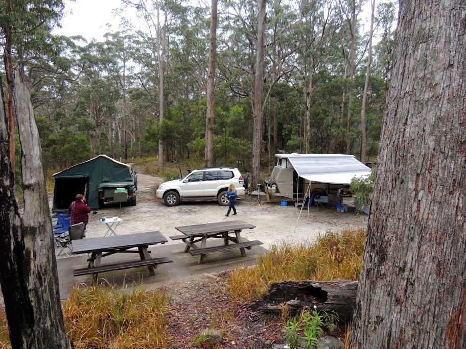
 Gum
Bend is a man-made recreational lake, fed by overflow from the Lachlan
River. A pleasant camping area lies beside the lake hidden from a view of
the water by a levee bank and it was here that we set up camp with space for
two more camper trailers to join us next day.
Gum
Bend is a man-made recreational lake, fed by overflow from the Lachlan
River. A pleasant camping area lies beside the lake hidden from a view of
the water by a levee bank and it was here that we set up camp with space for
two more camper trailers to join us next day.
After a cold night and a late breakfast we drove back into
town to browse around the shops and tourist information and scout a place
for dinner. Our travelling companions, Jeff, Carolyn, John and Debbie,
arrived mid-afternoon with the weather still bleak. We walked the 3
kilometre circumference of the lake before gathering for happy hour. Dinner
was at the Royal Hotel in a typical country pub dining room.
on to the Darling River
A cacophony of birdsong woke us next morning, happily to
clear blue skies.
The plan for today would take us past Cobar on the way to
joining the Darling River north of Wilcannia. Unfortunately, the wet
conditions had closed roads on our planned route; plan B saw our convoy of
campers detour via Mount Hope and north up the Kidman Way. After a road side
stop for lunch, another to collect firewood and refuelling in Cobar, we
pulled into Meadow Glen rest area on the Barrier Highway around 4pm.
 Behind
the rest area, red dirt tracks wind through the scrub with plenty of places
to set up camp for a quick overnighter. Soon, our campfire was burning and
producing coals for the night's damper and roast dinner - a worthy feast for
travellers!
Behind
the rest area, red dirt tracks wind through the scrub with plenty of places
to set up camp for a quick overnighter. Soon, our campfire was burning and
producing coals for the night's damper and roast dinner - a worthy feast for
travellers!
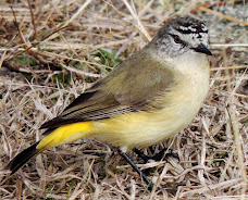
A cold and frosty morning greeted us the next day. While
the heavy mist hung around our camp, brightly plumed birds foraged among the
grasses and shrubs. Leaving Meadow Glen, we continued west along the Barrier
Highway racing towards our eagerly anticipated Darling River run. A late
morning tea at another roadside rest area was invaded by scores of curious
birds.
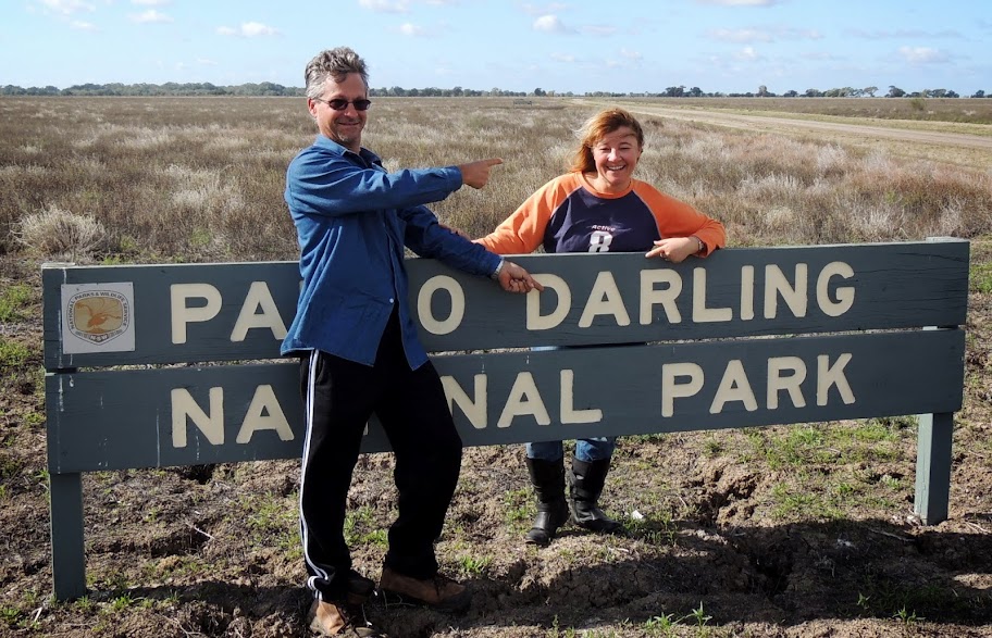
 About
5 kilometres shy of Wilcannia, we turned right onto the dirt headed towards
the southern section of Paroo-Darling National Park. The junction was marked
by the carcass of a sizeable wild boar; in the next few kilometres we passed
three parties of shooters.
About
5 kilometres shy of Wilcannia, we turned right onto the dirt headed towards
the southern section of Paroo-Darling National Park. The junction was marked
by the carcass of a sizeable wild boar; in the next few kilometres we passed
three parties of shooters.
The East Tilpa Road cuts a path across the vast Darling
flood plain and shadows the meandering course of the river itself. It took
about an hour to reach our destination: Coach and Horses Campground. Turning
off the road, we crossed a sandy paddock before entering a grove of trees to
find the most delightful campground with large camping sites spread around a
central grassed area shaded by stands of massive gum trees.
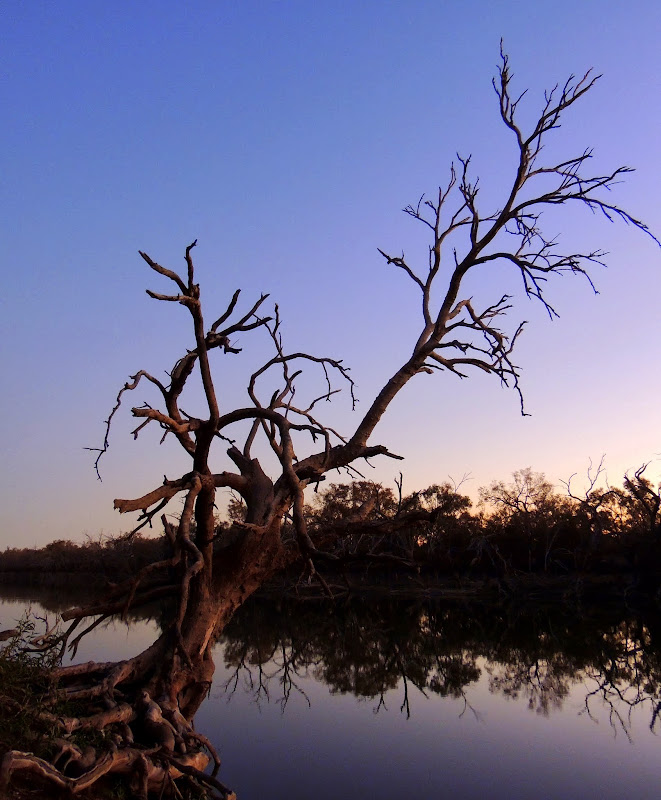
With no-one else around, we were able to take the pick of
the sites with a magnificent view over a broad bend in the mighty Darling
River. A few other groups arrived later in the afternoon to take other sites
but still there was plenty of room for all to have their own space.
 After
a late lunch, we took a walk heading north-east along the river clambouring
over enormous trunks of fallen gums and climbing the steep sided banks of
the river. Not for the last time on this trip, we regretted not having our
kayaks with us to be able to explore more from the water. Back at camp, we
enjoyed happy hour watching a glorious sunset over our small part of this
outback lifeline.
After
a late lunch, we took a walk heading north-east along the river clambouring
over enormous trunks of fallen gums and climbing the steep sided banks of
the river. Not for the last time on this trip, we regretted not having our
kayaks with us to be able to explore more from the water. Back at camp, we
enjoyed happy hour watching a glorious sunset over our small part of this
outback lifeline.
A leisurely morning saw us on the road again late morning
continuing across the flood plain, the green line in the distance to our
left a constant reminder of the river's location. The bridge at Tilpa
(population: 6) provides one of only two crossings over the Darling between
Wilcannia and Bourke. The name derives from the aboriginal word 'Thulpa'
which means flood waters.
 We
called in to the small pub for a chat and morning tea before finding our way
to the camping and picnic area at Tilpa weir for lunch and another stroll
along the river bank. The weir holds back some of the Darling's flow to
provide a water source for the local community and nearby properties.
We
called in to the small pub for a chat and morning tea before finding our way
to the camping and picnic area at Tilpa weir for lunch and another stroll
along the river bank. The weir holds back some of the Darling's flow to
provide a water source for the local community and nearby properties.
Retracing our route back past the pub, we continued along
the western side of the river on the appropriately-named West Tilpa Road.
After another stop to collect firewood, we arrived at
Trilby Station, our home for the next three nights, around 4 in the
afternoon.
at Trilby Station on the Darling
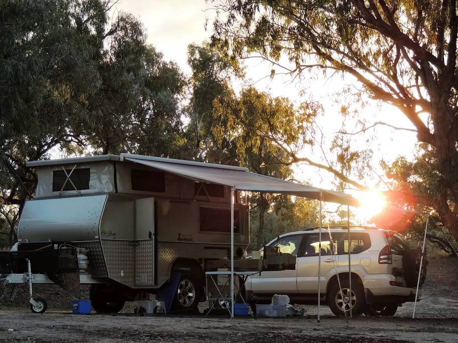
 An
hour later we had set up camp on the banks of Trilby Station's own
billabong, several hundred metres from our nearest neighbours camped at the
other end of the waterhole. As the sun set behind us, we watched the
changing shades of the soft afternoon light on the grand old river gums
lining the shore, feeling very much like the jolly swagman camped by a
billabong under the shade of the coolibah tree.
An
hour later we had set up camp on the banks of Trilby Station's own
billabong, several hundred metres from our nearest neighbours camped at the
other end of the waterhole. As the sun set behind us, we watched the
changing shades of the soft afternoon light on the grand old river gums
lining the shore, feeling very much like the jolly swagman camped by a
billabong under the shade of the coolibah tree.
In between cool evenings spent cocooned in the warmth of
the campfire and crisp, clear mornings taking breakfast by the still,
reflective waters of the billabong, we explored our surroundings on this
typical outback station.

A mudmap accompanied by descriptive notes guides visitors
on a 55 kilometre tour of the station. The route traverses vast, sparsely
vegetated paddocks and offers a look at key features of the farm: earthen
tanks, or dams, which provide water to livestock; an ex-army water tank
relocated to the station to provide additional water storage; stockyards
where animals are gathered to be freighted out to market; the rusting relics
of long abandoned vehicles and an old double-decker bus, once the residence
of a couple of old fencers who have since passed on.
During the drive, the terrain rises slightly from the
floodplain to higher ground where the soil changes abruptly from grey dirt
deposited by floodwaters to deep-red sand. Further on, the terrain rises
again onto harsh rocky ground as you approach the old homestead.

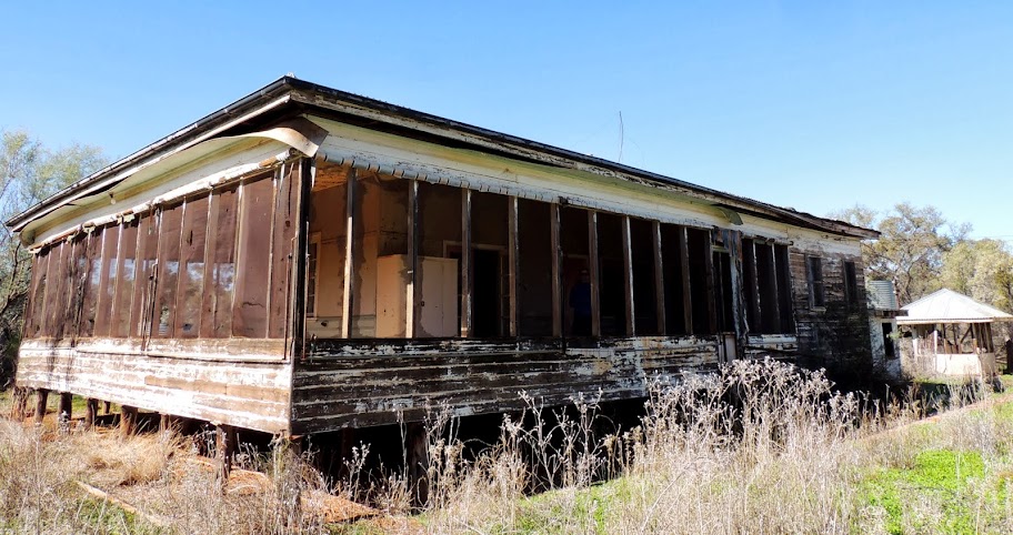
The homestead was abandoned when the family moved to the
present homestead near the river and today provides a glimpse into a life
since past. Remnants of once carefully tended gardens surround the old
timber building with its fly-screen enclosed wraparound verandah. Doors and
windows hang ajar on rusting hinges; farm machinery and vehicles lie
forgotten in the sheds.
Inside, a layer of dust blown in by windstorms covers
every surface. The beds remain made, books and magazines rest on tables no
longer read and in the kitchen, appliance brand names are familiar and
products from our childhood still stock the pantry.
When the family first moved, the intention was that the
old homestead would still be used from time to time by those working this
part of the property. Today, it has the air of a home abandoned when someone
walked out one morning and simply never returned.
Back at the billabong, Trilby provides a couple of kayaks
and canoes for use by campers. After the early morning mist has lifted from
the water, warm sun and still air in the late morning provided perfect
conditions for a 2 km paddle around the waterhole. We share the water with
pelicans gliding effortlessly around and small birds dancing between the
reeds and small trees while age-old gums stretch their limbs out from the
banks over the water.
 There's
an entirely different feel paddling the billabong in the late afternoon as
the sun slowly disappears behind the trees. Still water makes mirror-like
reflections, disturbed only by the ripple from a paddle dipped in the water
and birds shriek and squawk as they return to their nesting trees for the
evening.
There's
an entirely different feel paddling the billabong in the late afternoon as
the sun slowly disappears behind the trees. Still water makes mirror-like
reflections, disturbed only by the ripple from a paddle dipped in the water
and birds shriek and squawk as they return to their nesting trees for the
evening.
We also took time to explore the immediate area
surrounding our camp. Flocks of sheep and occasional goats graze of the
grassy paddock around the small airstrip which provides the only lifeline
when the property is isolated by flood. Across the paddock, there are a
number of campsites established along the high banks overlooking the Darling
River. Although we loved our spot by the billabong, these sites would
provide equally good camping.
After three blissful nights, it was time for our fellow
travellers to head home and us to continue on our journey.
to Cunnumulla on the Warrego River
After leaving Trilby, we continued east reaching the
small village of Louth, the second crossing of the river between Wilcannia
and Bourke. Louth was established in 1862 when an Irishman named Matthews
built a pub to cater for the passing river and land-based trade; it is now
famous as the location for the annual Louth Races.
We crossed the river to continue our journey on the
southern side of the river, stopping only to check out Yanda campground,
also on the Darling River and part of Gundabooka National Park.
After re-stocking and re-fueling at Bourke, we struck out
north on the Mitchell Highway, crossed the border into Queensland and rolled
into the outback town of Cunnumulla, our home for the next two nights.
 We
camped at a relatively new park about 3 kilometres out of town right on the
banks of the Warrego River. We opted for a bush site just behind the tree
line on the riverbank rather than the formal caravan sites the park offers
and headed back into town for dinner. The camp oven dinner at the Warrego
Hotel was accompanied by an old stockmen telling tall tales and cracking
stock whips.
We
camped at a relatively new park about 3 kilometres out of town right on the
banks of the Warrego River. We opted for a bush site just behind the tree
line on the riverbank rather than the formal caravan sites the park offers
and headed back into town for dinner. The camp oven dinner at the Warrego
Hotel was accompanied by an old stockmen telling tall tales and cracking
stock whips.
After a leisurely morning, we headed into town to explore
Cunnumulla. Again we wished we had brought kayaks with us - our plan to rent
for a paddle on the Warrego was thwarted when the operator had other
commitments for the day.
The Cunnumulla Fella Centre has a wealth of historical
information and displays and a very effective exhibit on the great artesian
basin. Outside, a bronze statue of the Cunnumulla Fella, inspired by the
Slim Dusty classic, gazes down the main street.
We follow the heritage trail around Cunnumulla passing
historic sites, drive tracks near the Cunnumulla sandhills, pass the
Robber's Tree and cross the Darby Bridge to do the Warrego River Walk in the
late afternoon. Back at camp we join in happy hour at the communal campfire
while the sun sets over dark, still waters of the Warrego.
to Broadwater lagoon then the coast
An early start next day saw us on the road by 815 heading
est out of Cunnumulla. Six hundred kilomteres later, after a lunch stop in
St George on the Balonne River (where are those damn kayaks!) and afternoon
tea at Moonie, we turned right into Lake Broadwater Conservation Area.
 We
set up the camper with a view of the lake as the sun set behind us and cast
a warm glow over the scene. A short walk along the lake yielded enough wood
to set a campfire to hold the cold night air at bay.
We
set up the camper with a view of the lake as the sun set behind us and cast
a warm glow over the scene. A short walk along the lake yielded enough wood
to set a campfire to hold the cold night air at bay.
After a spectacular sunrise, we drove on through Dalby
and the Sunshine Coast hinterland to camp at Dicky Beach. In the morning,
while the camper was attended to we enjoyed a cafe breakfast overlooking
Bribie Island (yes, we could have used the kayaks here) and later continued
on to Brisbane to overnight with family.
Bald Rock National Park
 After
a late morning and under leaden skies, we headed south back into New South
Wales and over the Great Dividing Range to Bald Rock National Park for a
two-night camp. Rob and Carol from the CamperTrailers Group joined us for
the first night and we had the place to ourselves on the second night.
After
a late morning and under leaden skies, we headed south back into New South
Wales and over the Great Dividing Range to Bald Rock National Park for a
two-night camp. Rob and Carol from the CamperTrailers Group joined us for
the first night and we had the place to ourselves on the second night.
Bald Rock is Australia's largest exposed granite surface,
measuring 750m long, 500m wide and 200m high. At 1,277m above sea level, the
peak of Bald Rock offers a spectacular 360 degree view of the surrounding
countryside. To get there, you have a choice of a short, steep scramble up
the face of the rock or a more leisurely and circuitous approach. Given the
wet conditions, we chose the latter.
Its a slow reveal : the walk begins at the day picnic
area and undulates through temperate rainforest and over creeks before the
track starts to climb slowly. Here and there you see large granite rocks
scattered though the bush, then larger boulders as the vegetation thins.
Higher up, massive boulders make you feel like you're walking through a
giant rock garden.
Along the way, interpretative signs provide guidance on
the geological history and formation of the site and the amazing variety of
flora: wild flowers and ferns, climbers and vines, down to the tiniest of
mosses and lichens clinging to the rocks.
 As
you wind around the monolith, huge tors and balancing rocks create a series
of corridors and tunnels before you eventually emerge from the tree line
near the top of the Bald Rock. Here, a series of four or five large round
rocks are lined up like billiard balls waiting for the cue stick to send
them tumbling over the edge. On the opposite side, Bald Rock falls
gracefully away to the valley floor 200 metres below, its face streaked in
beautiful shades greys and greens.
As
you wind around the monolith, huge tors and balancing rocks create a series
of corridors and tunnels before you eventually emerge from the tree line
near the top of the Bald Rock. Here, a series of four or five large round
rocks are lined up like billiard balls waiting for the cue stick to send
them tumbling over the edge. On the opposite side, Bald Rock falls
gracefully away to the valley floor 200 metres below, its face streaked in
beautiful shades greys and greens.
Fortuitously, the sun broke through the clouds just as we
sat down to admire the view and have a coffee and snack. The variety of
small plants which cling to life in crevices here at the top creates the
impression of a designer rock garden which would not be out of place in a
high-end home renovation.
With the rock face still wet from recent rain, we decided
not to tackle the climb down the face of the rock, instead retracing our
steps to return to camp.
not that Stonehenge
 Leaving
Bald Rock, we began the trek home down the New England highway. South of
Glen Innes, a small sign pointed to Balancing Rock, a roughly spherical
granite monolith about 2.5 metres in diameter, in a field to our right.
Backtracking a few hundred metres, we turned into a recreation reserve which
provides access to a large area strewn with more large granite boulders of
varying shapes and sizes. A variety of birds darted in and out of view as we
wandered around the area.
Leaving
Bald Rock, we began the trek home down the New England highway. South of
Glen Innes, a small sign pointed to Balancing Rock, a roughly spherical
granite monolith about 2.5 metres in diameter, in a field to our right.
Backtracking a few hundred metres, we turned into a recreation reserve which
provides access to a large area strewn with more large granite boulders of
varying shapes and sizes. A variety of birds darted in and out of view as we
wandered around the area.
The area is know as Stonehenge, an obvious reference to
the similarity in rock features with the English Stonehenge. The recreation
reserve is on the site of the now-abandoned, Stonehenge public school and
seemed like a good spot for morning tea.
last camp, last campfire...Quirindi Creek
 After
another pub lunch at Thunderbolt Inn in Uralla, we camped for our last night
beside Quirindi Creek in the small town of Wallabadah. Immediately adjacent
to the camping area, the First and Second Fleet Memorial Garden records the
names of all those who came out to Australia on eleven ships in 1788 on
stone tablets which stand in the gardens. The stories of those who arrived
on the ships, their life, and first encounters with the Australian country
are presented on storyboards along a meandering path through the garden.
After
another pub lunch at Thunderbolt Inn in Uralla, we camped for our last night
beside Quirindi Creek in the small town of Wallabadah. Immediately adjacent
to the camping area, the First and Second Fleet Memorial Garden records the
names of all those who came out to Australia on eleven ships in 1788 on
stone tablets which stand in the gardens. The stories of those who arrived
on the ships, their life, and first encounters with the Australian country
are presented on storyboards along a meandering path through the garden.
We had our last campfire for this trip on the grassy
slope by the bubbling waters of the creek before heading home next morning.
Images from this trip