|
Camping on Stockton Beach
camping is now not permitted
Worimi Conservation Lands Board of Management
draft plan
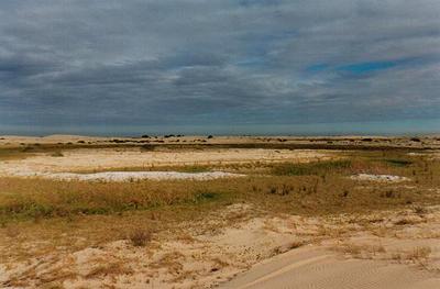
One of the joys of living in the Newcastle region is camping
on our own local Stockton Beach. For those members who are thinking of camping
there & have never ventured onto this 32 km wilderness stretch, here is a
little local knowledge to help you plan a safe trip.
GETTING
THERE
Birubi Point at Anna Bay
is the easiest & safest entry point to tow a camper trailer onto the beach. You
have two choices here. The first is from the 4wd parking area under the surf
club on the end of James Paterson Drive & the other is from the old sandpit,
which is sign posted `4wd beach access'. Both are off Gan Gan Road, Anna Bay,
although the latter can be a little soft in dry weather.
Don't forget the first
kilometre of beach is people only, so you will need to travel behind the
foredune until you reach the corduroy ramp which will bring you out onto the
beach proper. This northern end of the beach is usually much flatter & a little
firmer than the middle & southern end which can be very chopped up with heavy
usage & a trap for the unwary, even more so with a camper in tow.
The soft steep dunes off
Mac's Track at the end of Lavis Lane from Williamtown are not recommended to tow
a camper over & out to the beach front. The sand can be very powdery & even
bottomless in times of dry windy weather, but a downpour can change the
conditions into a hard track overnight. Not much fun bogged with a camper
trailer out there.
ON THE
BEACH
In normal times, low tide
often means the beach is hard & a trouble free drive down the beach from the
northern end at Birubi
Point can be made until the beach between high & low tide becomes too steep. Please note to exercise caution when driving below the high tide mark as soft spots can form in the
wet sand, particularly when the tide is dropping. These are not visible to the naked eye.
A speed limit of 40kmph applies at all times.
Please be aware that
people have the right of way at all times on the beach & a restriction of 20kmph
within 100m of pedestrians or vehicles applies. The first one kilometre from
Birubi Point is people only along the beach front.
The sand on the top
end of Stockton Beach is generally well packed making it easy driving. If you
have never driven on the sand before I would consider entering the beach from
the northern end in the company of an experienced sand driver, rather than via
the steep dune system from Lavis Lane.
On a king high tide or
after severe storms, it is sometimes necessary to stick to the track located
behind the foredune. After strong winds it can be hard to follow & will be soft
on the lee side of most dunes. Please also be aware that during these times it
will be quite dangerous driving behind the foredune as all traffic will be
forced onto the mainly single lane track & not all have your safety in mind.
Be careful around the
lagoons which form after wet weather. Quicksand forms which can quickly bog a
vehicle without warning. Best to keep back away from the edge of these.
Quicksand can also form at the base of the large dunes at the back of the beach
in wetter times. If driving alone take care as the quicksand can be covered by a
thin layer of dry wind blown sand. You will be axle deep without warning.
Whatever the conditions
local knowledge is the best advice & can be sourced from the METRO service
station on the round-a-bout at Lavis Lane, Williamtown or from the
MOBIL in Gan
Gan Rd, Anna Bay. Both stations also provide air outlets to pump your tyres back
up to highway pressures if you do not have your own pump, so there's no excuse
in not letting your tyres down for safe beach work.
BEACH PERMIT
A Worimi Conservation
Lands beach vehicle permit is necessary to drive on Stockton Beach &
replaces the previous Port Stephens Council
Stockton Beach vehicle permit. The permits can be obtained from the
above service stations which are close to both legal entry points. Don't forget
to ask for a copy of the Beach Vehicle Policy/Code of Conduct pamphlet when you
obtain your permit. They are obliged to hand one to you.
For further information
on the Stockton Beach permit & where to buy it from can be found in the
national park leaflet.
http://www.environment.nsw.gov.au/resources/parks/wclBeachDriving.pdf
|
BEACH VEHICLE DRIVING –
Code of Conduct
* Drive according to conditions -
speed limit of 40kmph applies & 20kmph within 100m of pedestrians or
vehicles.
*
Give way to pedestrians at all times.
*
Avoid reckless driving - for your safety and the safety of others.
*
Avoid launching off dune slopes.
*
Be prepared for dunes to conceal other vehicles - consider fitting your
vehicle with a flag.
*
Do not drive over vegetation - help keep dunes intact by following
previous tracks.
*
Do not drive over shell accumulations - you may damage cultural sites.
|
LET
YA TYRES DOWN
Letting your tyres down
will aid with flotation on the sand. 16 lb is a good start for both camper &
vehicle. Without erratic driving it is quite safe to lower the pressures down to
12lb which I normally use. Even two pound will make a huge difference to
floatation.
It is rarely necessary to
use your brakes on the beach to stop. I disengage the hydraulic over-rider
brakes on the camper. This stops the trailer digging in when your foot is lifted from the
accelerator.
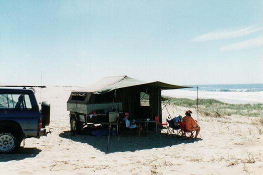
CAMPING
Camping is now not
permitted on Stockton Beach. Camping closures were put in place following storms
in June 2012 which were the largest to hit the beach since 1974.
http://www.environment.nsw.gov.au/nationalparks/parkCamping.aspx?id=N1111
The 4200-hectare
Worimi Conservation Lands are made up of three reserves: Worimi National Park,
Worimi State Conservation Area and Worimi Regional Park and are co-managed by
the registered Aboriginal owners and the Department of Environment and
Conservation NSW (DEC) under the direction of a Board of Management.
More information can be found on the
Worimi National Park page of the NSW National Parks website.
THE
WIND
Because Stockton Beach is
an open beachfront & is at the mercy of the elements. Of these, wind is the
worst & cannot be avoided. A strong southerly can hit the beach at gale force
strength & it is hard to guess how long it will last. At times the front may
blow over in an hour or it could last up to a day or more. A westerly is little
better, but can blow for days, with little or no protection at all. The summer
afternoon nor'easter can at times be very strong, whipping up white caps which
make it most uncomfortable. To move out of the wind, particularly in summer can
be very hot. Sand blows everywhere & we have at times packed up & headed for
home.
If you happen to get
blown off the beach there is the Birubi Beach Caravan Park located in James
Patterson Drive, Anna Bay, the One Mile Beach Holiday Park, Gan Gan Rd, Anna Bay
or at the southern end of the beach you will find the Stockton Beach Tourist
Park, Pitt St, Stockton.
KEEPING IT ALL TOGETHER
These conditions of
course put undue strain on the canvas of the camper trailer. I noticed with the
constant movement of the canvas the tent poles would work their way down into
the sand. Tightening of the ropes solved the problem of flapping canvas for a
short time, but eventually the poles would work down again & the canvas would
flap once more.
I finally solved the
problem by making up 300 mm square plates for the poles to rest on from 6mm
thick rubber, with a washer to locate the pole. Ply would also do the trick.
While I was at it I made
extra long sand pegs from 25x25x3mm steel angle approx. 600mm long. Now camp
sits where we made it.
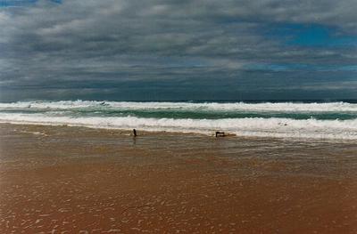
FISHING
If you are into fishing
Stockton Beach is one place you are more than likely to get yourself a good
feed. Spring is one of the slowest times as most years sees the beach plagued
with cold currents. But as the water warms up before Christmas & into the full
swing of summer there are plenty of whiting, flathead, chopper tailer & jew
about if you are keen to put the hours in.
Autumn sees the mullet
run followed by good sized bream & tailor, while winter has some of the best
tailor & salmon fishing on the coast.
WHAT TO SEE
The Shacks or Silver City
are a collection of huts built by fisherman over the years. You can find them
some 10 km down from the top of the beach.
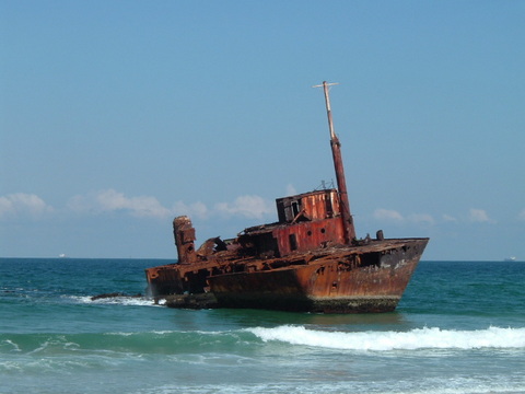
At around nine km down
the beach you may see the ribs of the Uralla if the tide is low & if there is a
bit of sand missing. She ran aground in 1932.
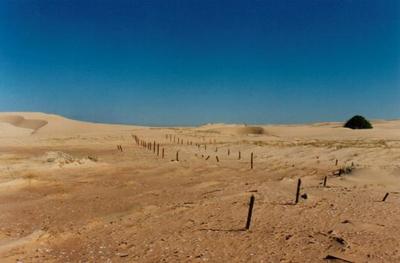
At numerous places behind
the foredune you will notice the remains of Newcastle's WW2 defences in the form
of tank traps, star pickets & barbed wire entanglements. There is also the
remains of a crashed Sabre jet which emerges from time to time.
At times the wind will
reveal Second World War air to ground bombs as the top end of the beach was a
practice bombing range. It was also not uncommon for planes to jettison their
unused bombs on their landing run coming back into Williamtown RAAF Base at that
time.
We found one such bomb
heading back to a favourite spot just south of Lavis Lane late one evening after
a fishing trip. Here you can sit high in the dune which is pushing into the bush
& hear the many bird calls echoing against the dune wall. We notified the police
who in turn notified the RAAF bomb squad. We took them out & showed them our
find. They then got out some plastic explosive & blew it up. They gave me the
steel detonator cap from the front of it. We now have that proudly displayed at
home.
You will notice piles of
white shells between the large hind dunes & the fore dunes. These are aboriginal middens or garbage heaps made from the deposit of marine shells such as pipis
off the beach &
whelks from nearly Tilligerry Creek after the animal inside had been eaten over
thousands of years.
In wetter times
rainwater will drain from the higher dunes at he back of the beach forming
freshwater lagoons in several locations. Although fresh on top these are usually
salt underneath as freshwater sits on the less denser saltwater.
Roughly seven km from the
southern end of the beach or six km south from Lavis Lane you will find the
stern section of the MV SYGNA stranded 26th May 1974.
http://www.robcaz.net/mv_sygna.htm
Most importantly
LEAVE NO TRACE
http://www.lnt.org.au/
LINKS
CO-MANAGEMENT AGREMENT
http://www.environment.nsw.gov.au/comanagement/StocktonBightCo-managementAgreement.htm
WORIMI CONSERVATION LAND BEACH DRIVING
http://www.environment.nsw.gov.au/resources/parks/wclBeachDriving.pdf
STOCKTON BEACH MAP
http://users.hunterlink.net.au/%7emadms/stockton.pdf
A TRIP DOWN THE BEACH WITH GRAHAM SANSOM
http://members.ozemail.com.au/~horizonsafaris7/
MEREWETHER BEACH LIVE CONDITIONS
http://www.stickybeek.com.au/webcams/merewether.aspx
FISHING REPORTS
http://www.fishingmonthly.com.au/pages/home.html
DUNES OF STOCKTON BEACH
http://www.portstephens.org.au/NaturalBeauty/i10.shtml
SAND DRIVING TECHNIQUES
http://www.pps.net.au/4wdencounter/4wdtech/sand_driving.html
|